
POPPKAD -
Example of property description in an original Popp matrice
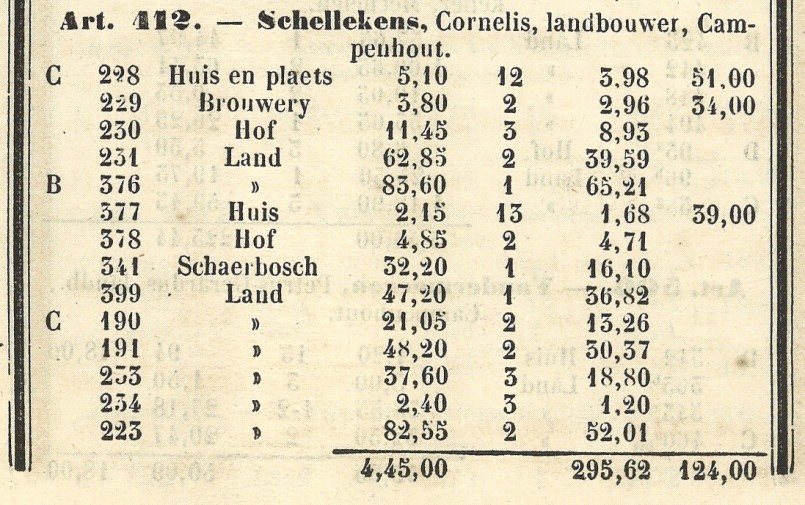
The land registry details as published by Popp follow a fixed structure in every matrice. The data is ordered per item, which corresponds to an owner or group of owners with the same commercial rights to a certain property in a municipality. In the top left we see the cadastral item number followed by the name, the occupation (at the time of registration) and the address of the owner. Beneath that is a list of all properties that the owner possesses in the municipality. The columns show: the cadastral neighbourhood section, the plot number, the type of plot or building and its surface area (expressed in centiares with commas for punctuation). This is followed by information about the value of the buildings as calculated by the land registry. The fifth column mentions the income bracket per type of plot or building; the smallest values represent the highest tax rates. The last two columns contain the property taxes of vacant plots and plots with a building on them. These amounts, expressed in frank, correspond with the net income that each property is estimated to yield the owner on an annual basis. At the bottom we find the sum of the surface areas and incomes per owner.
Search engine
Which owners and what information appears in the database?
Reliability and spelling of names
Search tips
Example of property description in an original Popp matrice
Where do I find the property description of a certain owner?
Why doesn‘t the names register cover all municipalities?
Where can I find real estate details related to the missing municipalities?
Manual for researchers
©: UGent, vakgroep Geschiedenis 2014