

ATLAS POPP
Various private individuals attempted to publish cadastral maps in the nineteenth century, but only Philip-Christian Popp left behind a work that transcends the local level. In January 1841 the former land registry official from Bruges received permission from the Finance Minister to publish an Atlas based on cadastral documents. This decision was the starting signal of an undertaking that would develop into an impressive magnum opus. For almost forty years Popp published the property maps and real estate registers of the majority of the kingdom.
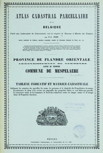
Popp's Atlas has more than 2000 maps and 30,000 register pages spread across 1736 volumes.
Each volume is dedicated to a municipality and contains the publication of the following land registry documents:
- the property map of the municipality in diverse scales (1:1.250 to 1:7.500) showing topographical elements like buildings, waterways and roads.
- the matrice: this register gives an overview of all plots classified per owner. In addition to the name, occupation and address of each owner at the moment of registration the register also mentions the type, surface area and taxable value of each plot or building.
- a summary of the different income brackets and a table with the total tax revenue in the municipality.
The Atlas covers an area where three-quarters of the Belgian population lived and where the national Cadastral Income was localised. The publication covers the provinces of Brabant, Hainaut, Liège, East- and West-Flanders completely except for six (pre-fusion) cities (Ghent, Geraardsbergen, Leuven, Liège, Ostend and Oudenaarde). For the province of Antwerp, the arrondissement Antwerp is partially published and Mechelen is integrally published.
A flaw in the Atlas of Belgium is the absence of a year. Except for a handful of municipalities, Popp omitted every date for commercial reasons. As part of the POPPKAD project, all the atlas volumes were dated accurately.